Augusta Township, Berks County
February 18, 1769 — March 21, 1772
By JOHN H. CARTER, SR.
When the Pennsylvania Assembly passed the Act of March 11, 1752 authorizing the erection of Berks County, it spelled out that a line should be run north-northwest to the extremity of the Province. Less than three years previously, the Treaty of 1749 had extended the northern extremity of the Province from the Kittatinny or Blue Mountains to a line beginning at the western extremity of Mahanoy Mountain twelve miles below the forks of the Susquehanna River and running North 600 East about one hundred and ten miles to the mouth of Lackawaxon Creek on the Delaware River. The Act of March 11, 1752 named Edward Scull of Philadelphia County, Benjamin Lightfoot of Chester County and Thomas Cookson of Lancaster County, commissioners to run, mark out, and distinguish the boundary line between the counties of Philadelphia, Chester, Lancaster and Berks. However, these commissioners did not extend the north-northwest line beyond the settlements.
Genealogical Chart of Berks County Townships
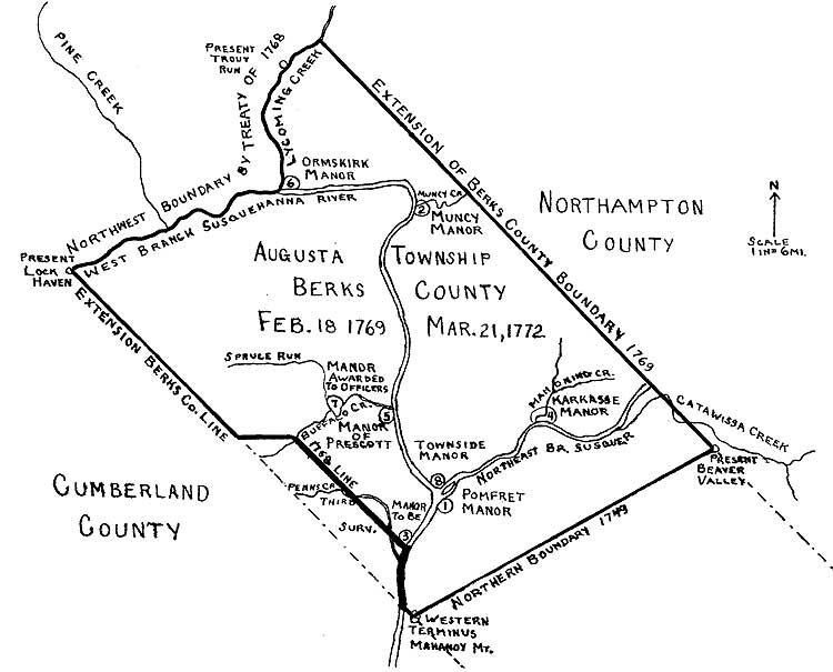
Map of Augusta Township, Berks Count
By the New Purchase consummated at Fort Stanwix November 5, 1768, the Six Nations conveyed to the Proprietaries of Pennsylvania all the land within the boundaries of the Province, extending from the New York line on the Susquehanna River, past Towanda and Tiadagton (Pine) creeks, up the West Branch of the Susquehanna, over to Kittaning and beyond. Less than four months later, on February 18, 1769, the Pennsylvania Assembly passed an act appointing William Maclay, William Scull and John Biddle, Jr., “to settle and fix the boundary line dividing the counties of Lancaster, Cumberland and Berks, and between the county of Berks and Northampton, by continuing the said due northwest courses from the south-east ends of the lines already run between the said counties, respectively, as far as the lands lately purchased by the Honorable Proprietaries of this Province from the Indians do extend.” Thus the northern boundary of Berks County was extended to an inverted U-shaped line with its western extremity near present Lock Haven and its eastern extremity at the present northern boundary of Lycoming County. This vast additional territory became Augusta Township, Berks County, and so remained until the erection of Northumberland County March 21, 1772. The history of Augusta Township, Berks County, therefore, covers a period of three years, one month and three days, from February 18, 1769 to March 21, 1772.
Strangely, on October 29, 1768, eight days before the consummation of the New Purchase, the Proprietaries awarded a special grant of 1090 acres including the mouth of Chillisquaque Creek to Andrew Montour for services rendered the Province. Another special application was issued in favor of the Reverend Dr. Francis Allison Feb. 4, 1769 for 1500 acres above the mouth of Bald Eagle Creek.
Following the New Purchase at Fort Stanwix and preceding the extension of the Berks County boundary lines, four warrants were issued in behalf of the Proprietaries, Thomas and Richard Penn, for surveying lands which fell within Augusta Township, Berks County. These four warrants made possible the establishment of six Proprietary Manors. (See Appendix)
The first, the Manor of Pomfret, was surveyed by William Scull, Deputy Surveyor of the Province Dec. 19, 1768. Within its 4,766 acres was Fort Augusta, which had been built in 1756 at the forks of the Susquehanna on Indian lands with their special consent.
Shortly thereafter Scull surveyed Muncy Manor on the warrant issued December 25, 1768 for 1615 acres including the mouth of Muncy Creek.
The third Proprietary Manor was surveyed by William Maclay on February 18, 1769, the very day the history of Augusta Township, Berks County began. It contained 1328 acres. The survey began about one mile north of the old mouth of Penns Creek, just above the Albany Purchase line of 1754 and extended northward along the Susquehanna River for 966½ perches. This was the first survey to be made in the New Purchase west of the Susquehanna and had been warranted Dec. 27, 1768.
The fourth warrant for the Proprietaries was issued Jan. 31, 1769 for 1000 acres and made possible the establishment of three Proprietary Manors. It called for 500 acres to be surveyed at the mouth of Lycoming Creek and 500 additional acres to be surveyed “in any part of the New Purchase that shall not interfere with any previous warrant.” On Feb. 22, 1769 William Scull surveyed the Proprietary Manor of Karkasse containing 180 acres and including the mouth of Mahoning Creek where a Delaware Indian village had stood, at present Danville, Montour County. The second Proprietary Manor surveyed on this fourth warrant was Prescott at and below the mouth .of Buffalo creek, the present site of Lewisburg, Union County. It was surveyed by William Maclay and consisted of 320 acres. One of the line trees blazed by Maclay in 1769 is still standing (1966) near the Lewisburg cemetery. The final survey on this warrant was run Mar. 20, 1769 including the mouth of Lycoming Creek. It was called Orms Kirk, and presently is part of the City of Williamsport, Lycoming County.
There was at least one permanent white resident living within the limits of Augusta Township at the time of its establishment. This was Colonel Samuel Hunter, Commandant of Fort Augusta. In 1768 the Proprietary Governor, John Penn wrote Samuel Hunter to continue to keep possession of Fort Augusta as before. Hunter occupied the commandant’s headquarters within the fort. He lived here during the Revolution and after the war continued to make this his home until his death, April 10, 1784.
The first lands to be surveyed (other than the Proprietary Manors), within Augusta Township after the extension of Berks county’s new boundaries were for the officers of the Pontiac War in payment for their services. On Feb. 3, 1769 the commissioners of these officers met at Governor John Penn’s and obtained an order allowing them to take up 24,000 acres, to be divided among them in distinct surveys on the waters of the West Branch of the Susquehanna, each 300 acres to be seated with a family within two years from the time of the survey. The names of the officers in whose favor the order of survey was issued were Colonel Turbutt Francis, Major John P. de Haas, Captains John Brady, Conrad Bucher, Timothy Green, James Hendricks, Nicholas Housseger, Samuel Hunter, James Irvine, Jacob Kern, Christopher Lems, William Piper and William Plunket; Lieutenants Thomas Askey, James Hays, Daniel Hunsicker, James McAllister, John Nice, Charles Stewart and Thomas Wiggins; and Ensigns Foster, McMeen, Morrow, Steine and Piper. This order of survey was signed by Surveyor General, John Lukens and directed to William Scull and William Maclay.
Later in February ‘many of the officers met at Fort Augusta and agreed to take the land upon the terms proposed by the Proprietaries, and that one tract should be surveyed on the West Branch adjoining Montour’s place at or near the mouth of Chillisquaque Creek, and one in Buffalo Valley. In order to expedite business, it was agreed that Captains Plunket, Brady, Piper and Lieutenant Askey should go along with Mr. Maclay to the Buffalo Valley and Captains Hunter and Irvine with Mr. Scull to direct the survey in the forks.
The Buffalo Valley survey was made on March 1st, 2nd and 3rd by Samuel Maclay, acting for his brother, William. This survey embraced the heart of the Buffalo Valley, a tract of 8000 acres, and, as their minutes say, “was made without opposition.” On the 16th of May, 1769, lots were drawn by the officers for the choice of lands. Captain Hendricks, having won the first choice, took the eastern end of the Buffalo survey. Captain Kern of Cumru Township, lower Berks, took the present site of Vixburg. The town of Mifflinburg was later founded upon the tract selected by Lieutenant Askey.
The West Branch or Forks tract was surveyed by Mr. Scull and contained 6096 acres. Contrary to common opinion, this tract did not extend from Chillisquaque Creek to the point at present Northumberland but reached northward from the region of Chillisquaque Creek to the present northern boundary of Northumberland County.
Following these two surveys, the officers again met at Fort Augusta and agreed that the remaining lands due them should be surveyed on Bald Eagle Creek. This third survey was made March 30th, 31st, and April 1st, 3rd and 4th, 1769 by Mr. Lukens. It embraced 8380 acres, which was 1524 acres short of what was due them.
When the officers met at Harris’ Ferry (now Harrisburg) on May 16, 1769, Messrs. Maclay, Scull and Lukens laid before them the drafts of their respective surveys, noting that the combined acreage was 1524 acres short of the amount of land to which they were entitled. The officers agreed that their former commanding officer, Colonel Turbutt Francis, should receive his share, 2,775 acres, surveyed to him in one tract adjoining the tract purchased by him of Andrew Montour. The officers then drew lots for the choice of the remaining lands along the eastern shore of the West Branch.
Above Francis’ tract, which extended northward about a mile above the present town of Milton, came the tract of Ensign Augustus Stein, 246 acres including the mouth of Muddy Run where later Captain Hawkins Boone built his mill and fort. Then came the tract of Captain Samuel Hunter, 609 acres, including the mouth of Warrior Run; then Captain Nicholas Housseger, a tract known as “Elmdon,” also 609 acres; next Lieutenant Daniel Hunsinger, 334 acres. Then Captain William Piper, another 609 acre tract on Delaware Run. North, along the river, was Lieutenant James Hayes, 334 acres. Captain Piper and Lieutenant Hayes settled on their lands and lived there the rest of their lives. Directly north of Hayes was Lieutenant John Nice’s tract of 334 acres called “Nice Bit”; and finally the most northern tract, 246 acres just south of the Muncy Hills, was awarded to Captain Jacob Kern.
But what about the 1524 acres deficit? Surveyor Lukens reported that Lieutenant McAllister, Ensign Piper, Captain Lems and Captain Kern yet lacked their shares in the Bald Eagle survey. Now lot number six had been surveyed for Ensign Morrow, but the Penns refused to grant him his land as he had participated in the rescue of Stump and Jroncutter, the murderers of the Indians on Middle Creek. Ensign Piper was therefore granted this tract. Three miles north of the officers’ Buffalo Valley grant there had been surveyed for the Proprietaries a tract of 1104 acres along Buffalo Creek. This tract the Penns agreed to grant to the officers to make up the deficit. Accordingly Lieutenant McAllister was awarded 290 acres, Captain Lems 527 acres and Captain Kern 287 acres.
With the exception of Colonel Turbutt Francis who received his full 2775 acres in one tract, fittingly called “Colonel’s Reward,” every officer received two tracts of land, each in a different locality. Each of the 48 separate plantations patented to these officers was given a special name, in many instances based upon the name of the officer to whom patented. Thus William Piper’s Buffalo Valley tract was given the martial name of Piper’s Parade; Captain Green s grant was called Green’s Grove; Captain Kerns land was given the name Kernton. The name which most intrigues me, however, is that given to Lieutenant Charles Stewart’s tract—Joyful Cabbin.
On April 3,1769 the land office was opened in Philadelphia to receive applications for warrants for surveys in the New Purchase. The astounding number of 2782 applications were received the first day. Many Berks County residents took advantage of this opportunity to obtain lands in the newly erected Augusta Township. The settlers from lower Berks came into Augusta Township via the Tulpehocken Road and the Kings Highway which terminated at Fort Augusta.
Numerous persons who settled in Augusta Township prior to 1772 were destined to play important roles in the American Revolution. Among these were Captain Hawkins Boone who was killed and scalped at the Battle of Fort Freeland, Colonel John Kelly, the hero of the Battle of Princeton, Major John Lee, who was massacred by the Indians while on furlough at his home at present Winfield, and Captain John Lowdon, who, on hearing the news of the Battle of Bunker Hill, recruited a company of ninety-seven men and set off for Cambridge. Lowdon had purchased a great deal of land in the Buffalo Valley in 1770 and his wife, Sarah, had in the same year received a patent in the forks of the Susquehanna at present Northumberland.
At least two mills were established in Augusta Township, Berks County; the mill of Ludwig Derr at present Lewisburg and the mill of Jacob Fought at the mouth of Cedar Run, near present Mifflinburg.
Although no churches were constructed in Augusta Township, congregations were organized, meetings were held in private homes, and children were baptized.
The first stone house to be built in Augusta Township is still standing along the West Branch of the Susquehanna about three miles northwest of present Muncy. It was built by Samuel Wallis, a wealthy Philadelphia Quaker, in 1769 on his 7000 acre tract known as Muncy Farm, in preparation for his bride. It was furnished with fine mahogany furniture made by the Philadelphia cabinetmakers, Wayne and Moore, and transported up the West Branch by batteaux. On March 1, 1770 Samuel Wallis married Lydia Hollingsworth, a Philadelphiaborn girl, and shortly thereafter brought her to their new stone home on the Pennsylvania frontier. The first white child born in the Muncy Valley was the son of Joseph Jacob Wallis, half-brother of Samuel. Joseph’s wife was the daughter of John Lukens, Surveyor-General of the Province.
That part of Augusta Township lying north of the 410 parallel fell within the controversial territory claimed by the Connecticut Colony as well as by the Province of Pennsylvania. Little wonder a controversy developed. Both colonies had legal claims to this land. The Yankee claim dated back to 1662 when King Charles II of England granted a charter to the Colonists of Connecticut which entitled them to govern themselves in a strip of land extending west to the Pacific Ocean and south to the 410 parallel. In 1681 he granted to William Penn a part of the same land which he had granted to the Colony of Connecticut 19 years previously. This Penn grant from Charles II extended northward from the 400 parallel to the 420 parallel, the present New York state line. As this overlapping territory was a wilderness in the possession of savage Indians it gave the English colonists no concern. However, three generations later 840 Connecticut Yankees banded themselves together under the title of the Susquehanna Company and at Albany on July 11, 1754 purchased from eighteen chiefs of the Six Nations land in the northern part of Penn’s grant for £2000 current money of New York. The purchase money was counted out in silver and carried by the Indians in a blanket into an orchard and there divided among them. Little wonder that trouble was brewing after the Treaty of Fort Stanwix in 1768 granted to the Proprietaries of Pennsylvania lands extending north from the Mahanoy Mountain to the New York border. The southern boundary of the Connecticut claim, the 410 parallel, ran directly through the forks grant to the officers of the Pontiac War. It cut across the West Branch of the Susquehanna about a mile below the present town of Milton.
Augusta Township was scarcely a year and a half old when the Connecticut Yankees arrived within its boundaries. In August, 1770 Major John Durkee, accompanied by Elisha Avery, a surveyor, and several other Yankees came to the West Branch to survey and sell land. The two following entries appear in the extant records of the Susquehanna Company:
“West Branch, Susquehannah, August 27, 1770 Received of William Speedy six pounds lawful money, which entitles him to one-half right or share of land in the Susquehannah purchase. Teste, John Durkee.”
“A survey of a tract of land being on ye river and up Lime Stone Run, known by that name. Done by order of Major John Durkee for Marcus Huling. Said tract contains 374 acres and 87 perches which survey was made ye 22nd day of September 1770. (Signed) Elisha Avery, Surveyor.”
Due to an error made by Samuel Wallis in the location of the 410 parallel, William Speedy’s tract was surveyed on Turtle Creek near present Winfield several miles south of the southern boundary of the Connecticut claim. It is believed Speedy was the only person to own and occupy property on a Connecticut title on the west side of the West Branch.
The tract surveyed for Marcus Huling Sept. 22, 1770 on a Connecticut warrant fell almost entirely within the Colonel’s Reward tract granted the previous year to Colonel Turbutt Francis by the Province of Pennsylvania. Huling occupied this tract shortly after the land was surveyed to him and built a log house at what is now the intersection of Broadway and Front Street, Milton, which house was destroyed by the British and Indians under Captain MacDonald at the time of the battle of Fort Freeland.
The Pennsylvania-Connecticut controversy reached its peak in the West Branch valley in September 1775 when 82 Yankees invaded the Warrior Run area, sent word to the Pennsylvania authorities of their intention to take up lands and be governed entirely by the laws of Connecticut, but were completely overcome by 500 Pennsylvania militia led by Colonel William Plunket. One Yankee was killed and several wounded, all the men were taken prisoners and their personal property confiscated.
In August of 1769 an unusual and important conference was held in Augusta Township. Seneca George, son of the Indian “Captain” Seneca George, had been killed a few miles below the mouth of Middle Creek. The Provincial authorities were very apprehensive that this might produce serious repercussions among the Indians. Peter Read, a relative of the late Conrad Weiser was implicated and lodged in the Lancaster jail to await trial. Colonel Turbutt Francis went to Philadelphia and reported the incident to the Provincial Council and impressed upon them the importance of immediately calling a conference with the Indians to be held at Fort Augusta and of presenting the elderly Seneca George and others with presents of condolence. A message of condolence was prepared in behalf of Governor John Penn by Mr. Logan and Mr. Peters. Francis returned post-haste to Augusta Township and immediately dispatched messengers to Seneca George to invite those concerned to meet with him at Fort Augusta.
On Saturday August 19 Seneca George arrived at the fort accompanied by the Conoy King, Last Night, The Onondaga Chief, Genequant and twenty two other Indians. Fifty inhabitants of Augusta Township also arrived at the fort for the purpose of attending Divine Services to be conducted by the Reverend William Smith, D.D., provost of the College of Philadelphia (Now University of Pennsylvania). Dr. Smith arrived at Fort Augusta just one half hour ahead of Seneca George and his retinue.
That afternoon Colonel Francis met with the Indians with Isaac Still acting as interpreter. Seneca George addressed the group and made two requests; that no strong drink be given to any of the persons on either side of the conference, and that food should be given to him and his party.
Learning that Divine Services were to be held at the fort for the white people who were assembled there, Seneca George sent word that since his people worshipped the same God as the English, they would attend also. Accordingly, Dr. Smith had a congregation of more than 125 persons, fifty additional residents of Augusta Township having arrived early Sunday morning. Rev. Smith directed the latter part of his discourse particularly to the Indians. Isaac Still interpreted it for them. The Indians conducted themselves with great ‘decency all during the services.
Most of the inhabitants of Augusta Township who had attended the Divine Services remained for the Monday conference. Colonel Joseph Shippen, Charles Stewart, and Frederick Weiser, son of Conrad Weiser, were also in attendance. Colonel Francis opened the conference by reading the letter of condolence sent in behalf of Governor Penn. He assured the Indians that if found guilty, the person responsible for the death of young Seneca George would be punished the same as if he had killed a white man. The Colonel then symbolically covered the body of the deceased Seneca George with a black shroud, took a handkerchief and wiped away his tears and sorrow, that they should grieve no more, with a belt of wampum, symbolically scraped up the blood that had lain on the ground so that it could be buried under the ground that neither Seneca George nor his friends’ eyes could behold it as they passed where the accident happened. Then taking another belt, Colonel Francis symbolically buried the body of young Seneca George so that none should bear the least ill will towards the English. Colonel Francis then delivered to Seneca George and his relatives the following presents from Governor Penn: A piece of Black Stroud, a piece of Black half thicks, a piece of Black Striped Duffills, two dark coloured Banbanoe Silk Handkerchiefs, six ruffled shirts, six plain shirts, two pieces of Scarlet and Star Gartering, 50 pounds of Tobacco, four pairs of shoes, four pairs of Buckles, fifteen gallons of Rum in three kegs, two pounds of Vermillion, one dozen Small Brass Kettles and two barrels of Pork. After the presentation of these gifts, Seneca George brought the conference to a close by stating that they had heard Governor Penn speak through Colonel Francis, and on the morrow would give an answer to what the Governor had said.
On Tuesday, Seneca George sent word that the Indians were not yet ready to reply. The conference was accordingly postponed until Wednesday. In the meantime nearly Fifty Delaware Indians, led by Chief New Aleke, though uninvited, came down the West Branch from the Great Island to attend the conference. The Nantikoke and Conoy refused to permit them to do so, stating they had no business in it. Colonel Francis sent for their leaders and informed them the conference was called for Seneca George and his relatives only. However, Francis gave them some provisions and rum and sent them home.
On Wednesday, when Colonel Francis reconvened the conference, both Seneca George and Last Night, the Conoy King, expressed satisfaction with the Governor’s speech. Last Night presented the Colonel with two strings of wampum and three belts. The conference then took a dramatic turn. Frederick Weiser asked permission to speak. Addressing the Indians he confessed that it was his brother who had killed young Seneca George; he spoke of the great love which his father had had for the Indians, that it was an accident which caused the death of the young Indian, but that if the court decided it was murder, the Weisers would not interfere with his punishment. He then presented Seneca George with a gift from the Weiser family which he told him was to wipe away his tears.
As Frederick Weiser spoke, Seneca George, who had been a staunch friend of Conrad Weiser, was filled with emotion. With tears, he arose and expressed his great friendship for Conrad Weiser. Slowly approaching the table where Colonel Francis and the other officials sat, he stated that he held no animosity for the Weisers, and suddenly grasping Frederick Weisers hand, he declared “I have no ill will to you Mr. Weiser, none to you Colonel Francis, nor to you Father (meaning Reverend Smith), nor to you Mr. Stewart.” As he spoke, he grasped each by the hand, and finally with outstretched hands toward the Augusta Township spectators, he said “Nor have I any ill will to any of you, my brethren, the English.” Thus was brought to a conclusion one of the most dramatic moments in the history of Augusta Township.
Many pioneers came into Augusta Township via the Susquehanna River and later used the river to transport by batteaux, canoe and flatboat their supplies. March 9, 1771 the Pennsylvania Assembly declared the Susquehanna River a public highway and appointed John Lowdon and Samuel Hunter, with eleven others, to act as commissioners to improve the river and certain tributaries and make them navigable.
There was one section of Augusta Township in which the Proprietaries prohibited any surveys or settlements to be made. This was the area between Lycoming Creek and Pine Creek. The Proprietaries were extremely cautious lest the Indians should be incited by settlements being made on land they had not intended to be included in the New Purchase. In the Treaty of 1768 at Fort Stanwix a section of the purchase line was defined as descending Tiadagton Creek to the West Branch of the Susquehanna River. The Penns were not clear whether by Tiadagton Creek the Indians meant Lycoming Creek or Pine Creek, hence the taboo. Despite this prohibition, settlers moved into the forbidden territory. Having no legal rights and being deprived of recourse to the courts, these daring frontiersmen formed a mutual compact among themselves and elected a tribunal of three of their own number whom they called Fair Play Men who were to settle any disputes among them, and it was agreed by all that their decisions should be final. It was finally established that the Tiadagton Creek of the Indians was Pine Creek and not Lycoming Creek. The settlers west of Lycoming Creek were allowed a right of pre-emption to their respective lands by paying a stipulated sum.
The year of 1771 saw a great increase in the influx of settlers into the territory of the New Purchase. The distance from Augusta Township to the county-seat of Reading worked an increasingly great hardship to the residents of Berks County’s remote township. The expediency of establishing a new county became more and more apparent. Accordingly, on March 21, 1772 the General Assembly erected the county of Northumberland. Sunbury, the seventh and last Proprietary town of Pennsylvania was laid out in the Manor of Pomfret as the county-seat. Thus, after a period of three years, one month and three days the history of Augusta Township, Berks County automatically came to an abrupt end.
APPENDIX
ERECTION OF MANORS.
Section XIX of the charter granted by King Charles II of England to William Penn provided for the erection of manors. This section reads in part as follows: “—AND by these presents WEE give and grant licence unto the said William Penn and his heirs — to erect any parcels of Land within the province aforesaid, into mannors—.”
Furthermore, of every 100,00 acres in the Province 10,000 acres be retained for the use of the Proprietor and his heirs, in contrast with the 90,000 acres for which the Proprietor or Proprietors were trustees. This gave rise to the expression, “manors or tenths,” and accounts for certain surveys being made “for use of the Proprietaries.”
Eight of these “manors or tenths” erected in Augusta Township, Berks County are herewith enumerated in chronological order and the derivation of their names recorded.
POMFRET MANOR. (Present site of Sunbury, Northumberland Co.) Named for the Earl of Pomfret, Thomas Fermor, father-in-law of Thomas Penn.
MUNCY MANOR. (Present site of Muncy, Lycoming Co.) Named for Muncy Creek which had been named for the Muncy Indians, one of the three divisions of the Lenni-Lenape, or Delawares.
FIRST MANOR WITHIN THE “NEW PURCHASE” TO BE SURVEYED ON WEST SIDE OF SUSQUEHANNA RIVER. (Between present Selinsgrove and Sunbury). Name unknown.
KARKASSE MANOR. (Present site of Danville, Montour County). Named for the Delaware Indian settlement of Karkasse which formerly stood at the mouth of Mahoning Creek.
MANOR OF PRESCOTT. (Present site of Lewis-burg, Union Co.). Derivation of name not known.
ORMSKIRK MANOR. (Present site of Williamsport, Lycoming Co.). Named by Reverend Richard Peters, Secretary of the Province, for the parish of Ormskirke in Lancashire, his first charge as a clergyman of the Church of England.
MANOR LATER AWARDED TO OFFICERS OF THE PONTIAC WAR. (Near present Buffalo Cross Roads, Union Co.). Name unknown.
TOWNSIDE MANOR. (Present Northumberland, Northumberland Co.). So named because it adjoined the proposed site of a town conceived by John Lowdon to be built upon the tract surveyed in the name of his wife, Sarah Lowdon. Later, but prior to the American Revolution, Reuben Haines, wealthy Philadelphia brewer, laid out the present town of Northumberland, using both Townside Manor and the Sarah Lowdon tract.
This article appeared in The Historical Review of Berks County, Summer 1967.